 |
| About us |
| Education Portal |
| The Team |
| Our Projects |
| Our Score Card |
| Partners |
| Sponsors |
| Media Coverage |
| Media Kit |
| Shopping Helps |
| Support us |
| Contacts |
|
Onward across the Pacific!
Climbing Kosciuszko -- Stage 2 of the Six Summits Project
Definition: What is Circumnavigation?
The goal of this phase
The goal of this phase was to make landfall in Australia during the human powered circumnavigation. There, Kosciuszko
(2,228 metres - 7,310 feet) in southeast Australia would be climbed.
The highest point in Oceania is the Carstenz Pyramid (Punjak Jaya). Located in Irian Jaya, also known as West Papua,
Carstenz rises to a height of 4,884 metres (16,023 feet). The first ascent of this mountain was
achieved by Heinrich Harrer in 1962, chronicled in his book titled: "I Come From the Stone Age."
Given the human powered restriction on the Six Summits Expedition,
climbing Carstenz required a sea-to-summit approach, meaning overland travel in Irian Jaya. Permits to travel within
Irian Jaya are notoriously hard to obtain and local tribes hostile to outsiders would rather charge a toll then
provide services for pay. All recent ascents of Carstenz to our knowledge fly to a nearby settlement, then receive
a helicopter ride to within a few days walking distance of the mountain. One party had to receive a total of nine(!)
permits even to fly in, any one of which could have been cancelled at a moment's notice. Negotiating passage through
tribal territories remained very difficult.
Planning a climb so far in advance with such strict permit requirements and so high an uncertainty made
the logistics impossible. The local contacts were not able to extend any help beyond the next few months.
So a compromise was necessary: We would take the classical definition of Australia being the continent,
leaving the climb of Carstenz to a future date when there may be peace on Irian Jaya.
Route details
NOTE: Please spin the globe to navigate.
If you do not have Google Earth, download it here.
On the globe, you will find a RED track with dispatch locations marked by date. This
indicates the path that the human powered circumnavigation effort followed. On the opposite side of the globe is the
antipodal circumnavigation track indicated in GREEN. Grey colored tracks indicate
time in transit by ship between PNG and the Philippines. If any of the tracks appear broken, then try toggling to "OpenGL"
in Google Earth's graphics preferences under Tools\Options.
Progress
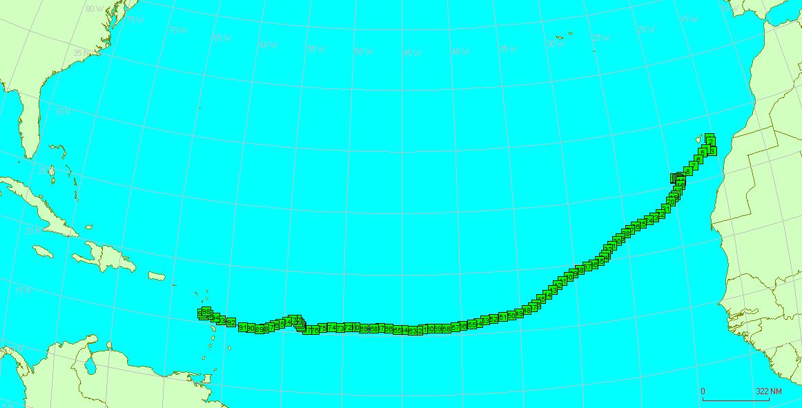
Between July 10, 2007 and May 17, 2008, Erden Eruç rowed from Bodega Bay on the California shores to the waters of
Papua New Guinea. The 312 days that he had spent in his rowboat became the new Guinness World Record for the longest
time at sea by a solo ocean rower. The previous record was 304 days, which belonged to the late Peter Bird, a
pioneer of ocean rowing who was lost at sea.
A full blown La Niña was in effect during the 2007-08 winter months that Erden spent on the Pacific with the
intentions of reaching Australia. The climate phenomenon known as La Niña brings cooler
conditions to the eastern Pacific. Consequently, stronger winds blow due west which push the warm ocean surface
waters westward. Warmer conditions thus created in the western Pacific then create heavier monsoons and more
cylonic activity. We suspect that it was due to these stronger winds that Erden was unable to cross the Equator
early on and failed to remain on track for Australia.
Being carried further north to face typhoons with little food on board was a recipe for disaster, which surely would
have created a rescue situation, risking the loss of the boat. The responsible seamanship required erring on the side
of safety and creating the least cost to those who would be coming to Erden's aid. Philippine fishermen on vessels
operated by the Frabelle Fishing Corporation
assisted in the "orderly retreat" helping to retrieve Erden's boat, and later stored it at the Frabelle facilities in
General Santos City on Mindanao Island in the Philippines.
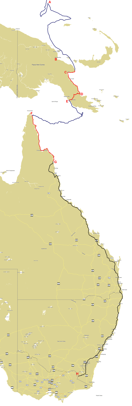
Erden returned to the Philippines and spent December there preparing his rowboat for a relaunch. On January 15 2009,
the boat was delivered to the same May 17 point (A) in the PNG waters. Erden rowed from there for an additional 20 days,
making landfall at Maneba Wharf in Finsch Harbor bay on February 4 2009. Offshore winds created by monsoon rains had made
landfall at Madang (B) impossible. With the vital assistance provided by Swire Shipping and Steamships
Shipping companies, Lae (C) became the base for logistics to store the rowboat and to stage the following legs of
the journey in PNG.
In September 2009, Erden walked from Maneba Wharf in the company of two villagers from Kamlawa, Philip Sigob and Christian Sami, who
had back in February come out to sea in traditional dugout canoes to greet Erden on arrival. Five days of coastal travel mostly
on the beaches and bush trails brought them to the Bukawa village, about 40 km east of Lae. They had to cross numerous creeks, ford
significant rivers and negotiate tight beaches during low tide.
October 2009 was when 20 days were spent sea kayaking from Bukawa to Oro Bay (D). Norman Watts from Washington DC joined Erden
on this stretch along the Solomon Sea shores of PNG. 223 nm miles were covered during which the sand flies offered the
biggest adversity to the team.
In November 2009, Doug Hilderbrand joined Erden to do a coast to coast trek across PNG from Oro Bay to Port Moresby (E). They began
the walk on November 11 at the Oro Bay Guesthouse, at the same spot reached by kayak. Kokoda Trekking Ltd, provided Wayne
Urina as a guide to lead the complete trek to the Royal Papua Yacht Club in Port Moresby. The team followed the roads to Kokoda,
negotiating river crossings due to damaged bridges from Cyclone Guba of November 2007. In Kokoda, they joined a formal trek over
the Owen Stanley Range following the historical Kokoda Track to Owers' Corner. Challenged by the heat, the challenging terrain and
the persistently wet conditions, the team survived this stretch, covering 168 miles (271km), reaching the yacht club on November 26.
December 8 was when Erden launched on the Coral Sea from the Royal Papua Yacht Club toward Australia. Unforecasted westerly
winds at the start and strong daily onshore winds every afternoon from the south caused by the land effects of PNG, dogged him
during the first two weeks of his crossing. The northwest monsoons had not yet started to neutralize these southerly winds.
Countless hours of rowing on precious little sleep got Erden across the Great Barrier Reef on December 31. He slept through
the New Year's Eve while resting on anchor inside the barrier reef. His ability to anchor in the shallow waters behind the barrier reef
gave Erden better control over his course toward land as he negotiated the winds and the strong tidal currents. Early in the morning
on January 10 of 2010, he dropped anchor at (S10.9610 E142.7225) next to Sharp Point at the mouth of the Escape river southeast of Turtlehead
island (F). Landfall was not permitted by Australian Customs anywhere but on Thursday Island, the official port of entry. This
concluded Erden's Coral Sea crossing on day 33.
Erden returned to the same point with a sea kayak on January 28, then paddled the far northeast shores of Cape York Peninsula due
south toward Cooktown (G). Cooktown was the farthest point where paved roads reached, an important factor during the rainy season. After staying
only three days there, Erden moved on by bicycle on February 18th. Multiple school visits were possible during the bicycle ride through
Queensland. The ride continued into New South Wales toward the Snowy Mountains. 3,607 km later, Erden reached the alpine village of Thredbo
under Mt. Kosciuszko (H), then climbed it on April 10th. Although a relatively easy hike compared to the high points of other continents,
Kosciuszko was special with its unique flora found nowhere else, its colorful snow gum trees, and its sacred context within the aboriginal
culture. Done together with Nancy Board, this section of the journey holds a special place in the Six Summits Project.
Background
In Stage 1 of the Six Summits Project
in 2003, Erden reached the summit of Denali (Mt. McKinley) by human power from his home in Seattle. He did this in the style of
Göran Kropp as a tribute to his fallen friend.
Later, between October 3rd and Christmas of 2004, Erden covered 3,980 miles across the Continental USA over 82 days. He achieved
this Göran style from Seattle to Miami, towing his personal climbing gear. The original plan had been to move the ocean rowing boat
around the world on a continuous path starting and ending in Miami. When further research discouraged the Miami departure, and
the Panama Canal proved a barrier, Erden's human powered circumnavigation
plans took a turn to leave from near San Francisco. Land phases would be introduced, and the boat would have to be shipped from one
side of a continent to the other.
Before continuing on with the Six Summits Expedition, Erden took a sabbatical,
and rowed solo across the Atlantic Ocean. The row had started in Lisbon as a pair, arriving at Las Palmas in the Canaries on
December 11, 2005. Erden later continued solo from Las Palmas until he crossed into the Caribbean Sea by the island of Guadeloupe,
becoming the 33rd person to row the Atlantic Ocean east to west singlehanded. | |||||||||||||||||||||||||||||||||||||||||||||||||||||||||||||||||||||||||||||||||
|
All Rights Reserved. |
 Completed: May 3, 2007 - April 10, 2010
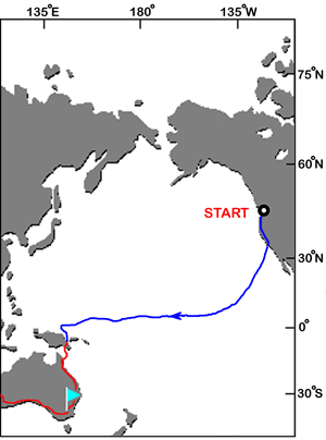
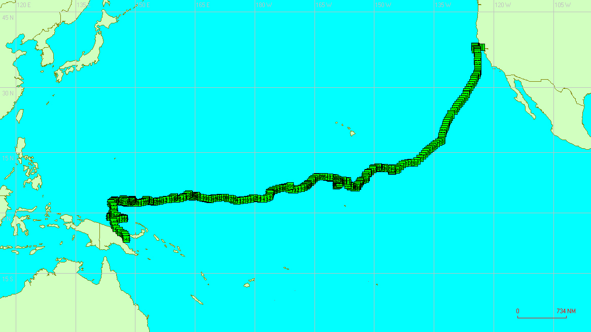
 In early May of 2007, Erden Eruç bicycled from Seattle to the Corinthian Yacht Club in Tiburon, on the north side
of the San Francisco Bay. Unfavorable onshore winds caused two false starts from Tiburon in June. The tide
schedules at the Golden Gate had been a major consideration on the launch windows from San Francisco. To remove
that extra constraint, the launch was moved to Bodega Bay, just northwest of San Francisco. A successful launch
finally followed on July 10, 2007 when the winds offered a break.
In early May of 2007, Erden Eruç bicycled from Seattle to the Corinthian Yacht Club in Tiburon, on the north side
of the San Francisco Bay. Unfavorable onshore winds caused two false starts from Tiburon in June. The tide
schedules at the Golden Gate had been a major consideration on the launch windows from San Francisco. To remove
that extra constraint, the launch was moved to Bodega Bay, just northwest of San Francisco. A successful launch
finally followed on July 10, 2007 when the winds offered a break. On May 14th, Erden reached the southmost position on his row when the seas turned on him. He had come to within 137nm
of Wewak in Papua New Guinea. He was between the Manu Island and the Ninigo Group. Just 200nm due southwest in Jayapura,
his teammates waited with 7 expedition bags full of resupplies. Alas, with 10 days worth of food left on board, Erden
was carried offshore, away from safety toward the storm tracks, with persistent southwesterly winds which later
turned southerly. The typhoon season had already started -- a typhoon had formed earlier on May 3rd northwest of Palau
which had created the sinking motion in the atmosphere, which in turn had brought the transient favorable north-northwest
winds helping Erden to break south of the Equator. Now the entire phenomenon had been reversed. The resupply was impossible
from Jayapura given the distances involved and lacking a suitable vessel.
On May 14th, Erden reached the southmost position on his row when the seas turned on him. He had come to within 137nm
of Wewak in Papua New Guinea. He was between the Manu Island and the Ninigo Group. Just 200nm due southwest in Jayapura,
his teammates waited with 7 expedition bags full of resupplies. Alas, with 10 days worth of food left on board, Erden
was carried offshore, away from safety toward the storm tracks, with persistent southwesterly winds which later
turned southerly. The typhoon season had already started -- a typhoon had formed earlier on May 3rd northwest of Palau
which had created the sinking motion in the atmosphere, which in turn had brought the transient favorable north-northwest
winds helping Erden to break south of the Equator. Now the entire phenomenon had been reversed. The resupply was impossible
from Jayapura given the distances involved and lacking a suitable vessel.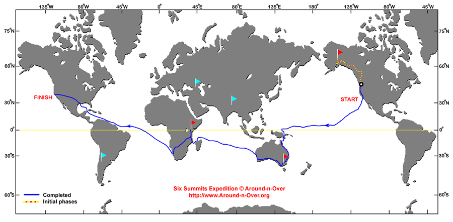